

Geology in Utah
I grew up in Midway, on top of hot-spring rock.
I'm a junior at Stanford in Earth and Planetary Sciences, with minors in physics and math. My research is radar in ice, in Stanford's Radio Glaciology Lab. Below is the ground between Utah Valley and my hometown, drawn west to east.
From Utah Valley to Midway
Schematic: heights are stretched, and places a little north or south of the line are drawn onto it.
- Oquirrh Formation: Pennsylvanian limestone and sandstone
- Jurassic and Triassic beds below the thrust
- Keetley Volcanics
- Valley fill
- Tufa
- Faults
Utah Valley
18,000 years ago. Lake Bonneville stood at about 5,100 ft (1,554 m), over 1,000 ft deep and about 20,000 square miles. It spilled at Red Rock Pass in Idaho and dropped about 425 ft in weeks to months.
After that flood, Lake Bonneville held at the Provo shoreline, about 4,740 ft (1,445 m), for more than a thousand years and built broad deltas where the big Wasatch streams came in. Those delta deposits make the Orem bench and sit under BYU's campus.
Sources: UGS: Lake Bonneville · BYU Geological Sciences
The Wasatch Fault
A normal fault about 350 km (220 mi) long, from Fayette, Utah to Malad City, Idaho, in ten segments. The Provo segment runs about 70 km along its trace; trenches date its last surface-faulting earthquake to roughly 500 to 650 years ago. The central segments make a magnitude 7 about every 900 to 1,300 years. GPS puts the stretching across the Wasatch at about 1.7 mm a year. The range front shows it: triangular facets where the ridges end, and scarps in young deposits.
Sources: USGS: Wasatch Fault earthquakes · Provo segment trenches · GPS across the Wasatch
Mount Timpanogos
Timp tops out at 11,749 ft (3,581 m). Most of it is the Oquirrh Formation: Pennsylvanian limestone and sandstone laid down in a shallow sea, then carried more than 30 miles east on thrust faults. Timpanogos Cave, in American Fork Canyon, formed along three small faults in the Mississippian Deseret Limestone, about 340 million years old.
Sources: UGS: Mount Timpanogos · NPS: Timpanogos Cave geology
The cirques
18,000 years ago. In the last ice age, ice built up above about 8,200 ft (2,500 m) in northern Utah and filled the cirques on Timp's east side. Only the Bells and Little Cottonwood Canyon glaciers, north of Timp, reached Lake Bonneville, and the Wasatch Fault cuts their moraines. Few studies have mapped how far down Timp's ice reached, so the tongue in the drawing is a sketch.
Glaciers carved the bowls below Timp's summit ridge: Emerald Lake sits in a cirque, and Timpanogos Basin and Cascade Cirque are others. Moraines and till around Timp record three times the glaciers grew. Utah's last glaciers melted out 8,000 to 7,000 years ago, and since the ice ages only rock glaciers have sat in Emerald Lake's cirque. The "Timp glacier" above the lake is one: rubble over ice. A University of Utah gravity survey found it is about 83 percent ice, about 1.5 million cubic meters.
Sources: UGS: Utah's glacial geology · NPS: Timpanogos Cave geologic report · UGS: Mount Timpanogos · University of Utah: hidden ice
Deer Creek and the Charleston thrust
Timp's rock rides on the Charleston thrust, which runs through the ground around Deer Creek Reservoir. Above it is the Oquirrh Formation; below it are Jurassic and Triassic beds that dip southeast. Rocks of the same age, Late Mississippian to Permian, are about ten times thicker above the thrust than below it, so it brought together rocks laid down far apart. On the Charleston-Nebo thrust these rocks moved 30 to 50 miles east about 80 million years ago. Later, in the mid-Tertiary, the Deer Creek fault, a normal fault, dropped rock several thousand feet east of Timp. Deer Creek Dam, a 235-ft earthfill dam with its crest at 5,425 ft, holds the Provo River at its southwest end; the reservoir fills to 5,417 ft (1,651 m) and reaches back toward Heber Valley, whose fill, up to about 800 ft thick, is the valley's main aquifer.
Sources: UGS: Charleston quadrangle map · NPS: Charleston thrust and Deer Creek fault · UGS: Charleston-Nebo thrust · Reclamation: Deer Creek Dam · USGS: Heber Valley groundwater
The hot pots in Midway
Rain and snowmelt sink along faults and fractures, warm up at least 5,000 ft down, and come back up. At the surface, carbon dioxide bubbles out and calcium carbonate settles as tufa, building mounds over hundreds of years. There are several dozen pots, 54 to 104°F. Homestead Crater is over 200 ft across and 55 ft high, with water more than 65 ft deep at about 95°F. No magma is needed: water this warm comes from ordinary heating with depth. UGS has written both that the water falls on the Wasatch west of town and that it soaks in to the north near Park City.
Sources: UGS GeoSights: Midway hot pots · UGS: geothermal in Utah
The Keetley volcanics
Northeast of Heber Valley are the Keetley Volcanics, up to about 1,500 ft thick, from volcanoes active 35 to 33 million years ago.
Sources: UGS: Wasatch volcanoes · USGS Geolex: Keetley Volcanics
What I'd bring

Radar and dielectric measurement
I measure how brine changes the permittivity, attenuation and reflectivity of an ice analog with a vector network analyzer. It's the physics under ground-penetrating radar, and the same lab uses radar to see through glaciers and ice sheets on Earth.
Fieldwork in Wasatch County
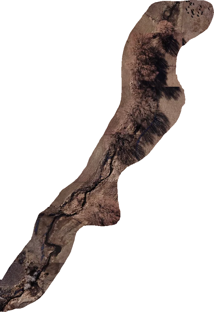
In high school, with the Utah DNR through Wasatch CAPS, I designed the drone survey and transect protocols for our ecological fieldwork and led the student ecology team. An early aerial survey helped save century-old willows during campus construction.

Code
Python with NumPy, SciPy and Matplotlib for the lab data; Astropy and IRAF/PyRAF for reducing telescope spectra at KIPAC.

I'm looking for a research internship in Utah for summer 2027. If you have room for a student, I'd like to hear from you.
Write to me